14 Miles
We breakfast, pack and leave Laurel Cottage to wander back through the hamlet of Redwick to make our way to the coast path. A slight detour takes us into the 12th century church to see the baptistry pool, one remaining stained-glass window (after the rest were ruined by a stray WW11 bomb) and the mark of the Great Flood of 1606 – it’s crazy high. After re-reading the South Wales coast path book last night I’ve realised that there is an easier way back to the coast – wish we’d known about Sea Street Lane yesterday, our boots wouldn’t be quite so muddy!
What a joy to see blue sky over what now looks more like ocean than estuary – mini waves are lapping at, almost, a sandy beach below the sea wall. Looking back, we can still make out the sweep of the Severn Bridge, ahead the grass topped, winding sea wall and to our right a bed of bronzed reeds and grassy fields with sheep and lambs bleating.
The going is fairly easy until we come to one section with hoof prints galore, the guilty parties enjoying their breakfast in an extremely muddy corner of the field. They look up as we pass through the gate into the “Private Grounds” of a very pink house, its Welsh Flag flapping in the breeze atop a brand new flag pole.
Soon the route diverts away from the seawall, to avoid disturbing wildlife in Gold Cliff Pill. Although we wouldn’t have been tempted, it looks like the Sea Wall Tearooms have closed for more than the season. A “For Sale” beckons new residents.
The path heads perpendicular to the sea then left onto the nature reserve, signs requesting us to “look after the reserve’s wildlife” by keeping our dogs on a lead. It’s a picturesque but muddy walk, alongside and over the numerous reens (a Welsh term for drainage ditch). We pop our head into a bird hide, a disappointed twitcher just packing up. Onwards the route gets muddier before popping out onto a small lane on the outskirts of Goldcliff.
There are brand new farm buildings – large steel ones and a gorgeous new stone crafted building, then just around the corner is a fenced off construction site. The construction company Kier are repairing flood defences. The coast path signs guide us round the heras fencing. Looking back, we missed the Farmers Arms pub, but sadly, no time to stop today.
We get confused over the next section, it seems we should have stuck close to the fence line, but end up between the reens, having to make the decision to cross one towards the end. Luckily no muddy ingress. Through a gate and we stop for a snack by the sign explaining why the coast path still cannot follow the coast, so we politely head away to help protect the wildlife’s habitat.
Thankfully its not too far on this stretch of road, I stop to admire a stunning spreading pine (I believe Pinus nigra) in the front garden of a stone cottage. We criss-cross a few fields and muddy alleys before yet another short stretch of road, then finally popping out by the sea again. It’s so good to see the sun glinting on the water, with what I think is the Somerset coast on the horizon.
We are now in the Newport Wetlands which was established in 2000 by the RSPB, Natural Resources Wales and Newport City Council to mitigate losses in construction of Cardiff Bay. The 437 hectares of open grassland, lagoons, mudflats and reedbeds are intersected by reens and pathways, making a very pleasant place to meander through. As we walk the coast path, around the outskirts of the site, I catch my first glimpse of our holiday home for this evening – the West Usk Lighthouse.
Stop for photos at the working East Usk lighthouse (2 flashes every 10 seconds) then it’s time for lunch. I’m looking forward to getting to the Visitor Centre but, despite all the signs directing us to it, the coast path continues round the edge eventually emerging at the visitor car park. The large steel sign and glass fronted modern low-lying building are a welcome sight.
It’s a tough decision between Welsh Cakes or Bara Brith, but we go for the cute little fruit dotted Welsh Cakes which are yum. We join the bird watchers at the large windows overlooking the pond, I spot coots in the reeds and a long-tailed tit on the feeders, but that’s as far as my bird knowledge extends today. The display cabinets show off the differences between the interwoven bird nests, the reed warbler nest being the cutest. The international arrivals board informs us of the successful arrival of Reed warblers from Dakar and Whitethroat from Timbuktu – ingenuous.
It’s 2pm and we need to continue to Newport then back to our car at Chepstow and on to our holiday home. We are the only people leaving on the extremely muddy coast path out of the Visitor Centre. We cross a few fields, finding ourselves on the wrong side of a reen as we pass the Waterloo Inn at Nash, we just about manage to straddle some gates and cut across to the exit gate.
Cross the road to Great Traston Meadows, where apparently “waves of colour flow across the reserve’s hay meadows throughout spring and summer months”. Well, I can safely say that March isn’t a spring month … the drainage ditches spread like a mosaic across the fields, and we frequently find ourselves on the wrong side of one as we head from metal gate to metal gate. At least it’s well signposted.
This leads to a wide path through wood scrub, a high fence to our left and the whirr of two rotating windmills poking their heads above the tree line. Then suddenly we’re on the litter strewn paths around a noisy manufacturing site. Signs for Port Harcon Shipping and Liberty Steel Newport stand high above more litter than I’ve seen for a very long time. Big lorries shuttle past us.
We are pleased to leave the area on a newly constructed path, cranes piercing the sky the other side of a waterway, boats moored above the muddy bank. We take the bridge over a pipe way to find ourselves on a newly landscaped strip of land, along the water’s edge. Rusted Corten steel bolsters the new path with smart silver-grey handrails. We admire the array of newly planted trees and shrubs and benches.
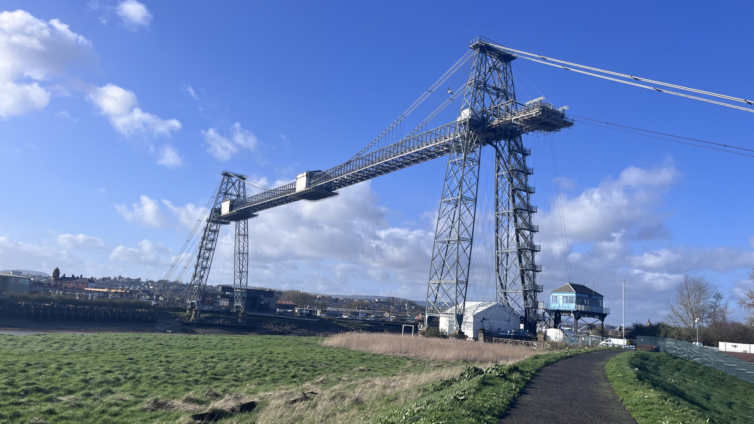
As we turn the corner, we get our first complete view of the Newport transporter bridge spanning the River Usk. To our right the very new and very smart looking Coronation Park with playing fields, play equipment and a dog training area.
Sadly, we will not be crossing the River Usk at this point – they are in the midst of a transformation project. We take some snaps against the blue skies then continue through an alleyway behind the construction site onto Stephenson Street. Take a left at the driving test station and along the busy Coronation Road, which slowly turns from industrial to residential.
Take another left down the very busy Spytty Road and across Newport City Bridge. The rush of cars on the road takes away from me admiring the quite impressive 190m steel arch bridge, which only opened 20 years ago in 2004.
I snap a piccie of a derelict brick building on the far side then stop the Wales Coast Path app and work out our way to the railway station. We decide the Usk Way is too busy so opt for a very interesting wander up Commercial Road. I’m quite relieved to arrive at the busy station and jump on the busy commuter train to Chepstow.
Leave A Comment